|
| |
|
The Handy Guide To Swaledale (No2)
Printed and published by Northern Echo, Freemans Place, Darlington
|
|
[Partial content relating to Upper Swaledale
only]
|
|
The Handy Guide To Swaledale (No2)
- page 48
HEALAUGH
About a mile from Reeth on the road to Muker, is the straggling
village of Healaugh, or Helah, formerly of importance as head
of the manor which included Reeth, Muker, and Melbecks. John
of Gaunt, Duke of Lancaster, well known in history, had a
mansion or fortress in the field still known as Hall Garth.
Maiden Castle (see Reeth) is easily reached from Healaugh,
the lane at the E. end leading to stepping stones across the
river, practically opposite the entrenchment.
About a half a mile to the W. of the village is Low Whita
Bridge, giving access to the S. side of the Swale. The road
to the L. leads to Grinton, and to the R. to Isles Bridge,
skirting Crackpot to Gunnerside.
The lane to the N. at the W. end of the village leads to
Park Hall, built in 1700 by Thomas Lord Wharton, an extensive
land owner in the district. Further along the lane is the
village of Kearton, from which district sprang the ancestors
of the brothers Kearton, so well known for their camera studies
of bird life. The track to the R., just before Park Hall is
reached and along the R. hand side of the beck, leads to the
disused Old Gang lead mines.
FEETHAM
From Healaugh the main road crosses Barney Beck and drops
down to Feetham, where the Punch Bowl Inn is well known to
tourists as a calling place. The church of Melbecks parish,
which includes the hamlets of Healaugh, Kearton, Low Row,
Feetham, Gunnerside, and several smaller places, is situated
at Feetham. The church is a modern structure, erected in 1841
and restored in 1866. The vicarage, situated
The Handy Guide To Swaledale (No2) - page
49
at the bottom of Crackpot Hill, on the S. side of the Swale,
about a mile and half W. of the church, was for thirty years
prior to 1912, when he retired from the vicariate, the home
of the Rev. R. Taylor, the well-known author and antiquary.
The foot ford across the Swale was used by the Romans in
their marches from the Harkerside encampment to Greta Bridge.
LOW ROW
Population - About 160.
Early Closing Day - Wednesday.
Places of Worship - Parish Church at Feetham, services, 10-30
a.m. and 6-30 p.m. ; Wesleyan Chapel, 2 p.m., 6-30 p.m.; Congregational,
2-0 p.m. and 6-30 p.m.
Literary Institute, Reading Room, and Library.
Post Office - Open 9 a.m. to 7 p.m., weekdays. Delivery of
letters commences 8-40 a.m.; despatch, 3-15 p.m. No delivery
or collection on Sundays. Telegrams; Telephone.
Railway Station - Richmond (13 miles).
Distances - Reeth, 3 miles; Askrigg, 6 ; Muker, 6; Gunnerside,
3.
Almost adjoining Feetham is Low Row, a village which, like
its neighbour, is becoming increasingly attractive to summer
visitors for its easy access to the moors. From the long hillside
green which stretches the full length of the two places, typical
views of Swaledale are obtained. Full of charm is the outlook
over Crackpot Gill and up towards Summer Lodge.
The Congregational Chapel at Low Row was founded in 1690
by Philip Lord Wharton. This church was licensed under the
Five Mile Act - it was five miles from Grinton and Muker churches
- and for many years was the only Nonconformist place of worship
in the dale. The present Congregational Chapel was built in
1809. It was this same Lord Wharton who gave an estate in
trust for the purchase of 1,050 Bibles yearly, and these are
known to this day as the "Wharton Bibles."
A short distance W. of Low Row, a lane to the L. crosses
the Swale by Isles Bridge. A turn to the R. and then L. alongside
the gill, brings the visitor to the small hamlet of Crackpot.
The gill (the wooded banks of which are rich in fern and lichen
and wild flowers) rises on the moor above Summer Lodge, near
Summer Lodge Tarn. Near the source of Crackpot Gill (about
a mile from the village) is a curious cavern known as Fairy
Hole. The entrance is very narrow, but a spacious
The Handy Guide To Swaledale (No2)
- page 50
chamber opens out inside. At the further end of the cavern
a stream of water issues from the rock, and falls into a pool
or well below. The gill forms a pretty waterfall near to the
highway, not far from Feetham vicarage.
In the neighbourhood of Crackpot, tradition asserts that
a fight took place between some Scots and Dalesmen. At any
rate, in 1847, seven human skeletons were unearthed near Melbecks
vicarage, and from a buckle of a sword belt and other articles
found near, it is assumed that they were followers of the
Young
|

Low Row (Photo by Valentine & Sons, Ltd.)
|
Pretender who had been killed in an affray in the vicinity.
"Bloody Vale" is the name given to that part of the
moor through which flows one of the feeders of Crackpot Gill.
The rough road beyond Summer Lodge continues over Askrigg
moor, - where the becks take a southerly direction into Wensleydale
- to Askrigg. Above Askrigg Town Head the road joins another
one crossing the same wild moorland track by High and Low
Oxnop to Muker. The former road is known as the Street, indicative
of a Roman road which crosses the moor. It was while crossing
the moor into Wensleydale that John Wesley, after one of his
visits to the district, had his horse bogged, as recorded
in his journal.
The Handy Guide To Swaledale (No2) - page
51
Distance to Crackpot: 1 mile; to Summer Lodge: 2 miles; to
Summer Lodge Tarn: 3 miles; to Askrigg: 5 miles.
The Old Gang Smelting Mill and the Old Gang Lead Mines can
be reached by footpaths over the moor to the N. of Low Row.
Distance: to the mill, 1¼ miles; to the mines, 2½
miles.
GUNNERSIDE
Population - About 300.
Early Closing Day - Wednesday.
Places of Worship - Mission Church in connection with Melbecks
Parish Church, service, 2 p.m.; Wesleyan Chapel, 2 p.m., 6-30
p.m.
Literary Institute, Reading Room, and Library.
Post Office - Open 9 a.m. to 7 p.m., weekdays; 8-30 a.m. to
10 a.m., Sundays. Delivery of letters commences 9 a.m.; despatch,
3 p.m. Money Orders; Telegrams; Telephone.
Railway Station - Richmond (16 miles).
Distances - Askrigg station, 5½ miles (rough road);
Muker, 2¾; Reeth, 6.
Gunnerside is a typical mountain village, and is the largest
in the dale with the exception of Reeth and Grinton. The valley
contracts here, and the hills are wilder and more precipitous
than near the villages in the lower part of the dale. The
village is astride Gunnerside Gill, which rushes down a deep
gorge from its source four miles up the hills between Rogan's
Seat and Water Crag. The beck is margined by limestone scars
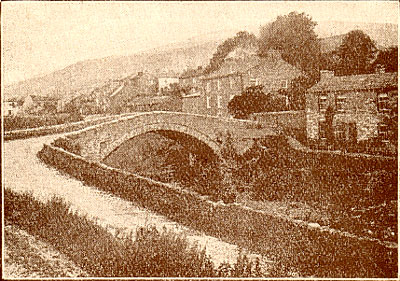
and joins the Swale by Gunnerside Bridge, S. of the village.
Here, in times of flood, the river has tremendous power, and
in January, 1890, the bridge was washed away. The present
substantial structure of two arches replaced the one destroyed.
The walks round the village include some of the wildest scenery
to he found in Swaledale.
First in importance should be placed a walk up the deep wooded
gorge through which flows Gunnerside Beck. The footpath on
the L., or W. side, of the beck should be taken from the village,
and the walk may he continued to the summit of Rogan's Seat,
2,204 ft. high, or by turning L. and veering S. the return
journey may be made via Ivelet on the N. bank of the Swale.
The ascent of Rogan's Seat means a walk of eight or nine miles,
and the shorter journey by Ivelet is about five miles.
The Handy Guide To Swaledale (No2) - page
52
A more strenuous walk is to include the ascent of Water Crag
(2,188 ft.) as well as that of Rogan's Seat. The summits of
the two mountains are barely a mile apart. The space between
is Wham, or Swamp, Bottom. Water Crag is well named, for it
possesses more water courses than any other hill in the locality,
its northern slopes providing gathering grounds for numerous
streams which flow into the Arkle Beck. From Water Crag there
is an extensive view of Upper Arkengarthdale, and across Bowes
Moor and Stainmoor.
Tanhill Inn is a good two miles N.W. of Water Crag. It is
the highest inn in England, being 1,727 ft. above sea level.
The Cat and Fiddle, on Axe
|

Gunnerside (Photo, Gowing, Bedale) |
Edge, Cheshire, sometimes claimed to be the highest, is 1,690
ft. high. In addition to being the highest inn, Tan Hill may
justly claim to be the loneliest.
The time taken in undertaking the ascent of Rogan's Seat and
Water Crag should not be reckoned in mere miles owing to the
nature of the country, and ample allowance should be made.
Ivelet Beck is a mile W. of Gunnerside. Cross the common,
passing Dyke Head (where was born the poet Close). Ivelet
Falls are close to the village, and about half a mile higher
up the beck are the charming Yew Scar Falls, where the water
falls over a limestone precipice and in three leaps descends
100 ft. Return by the field path nearer the Swale, making
a total distance of three miles.
The Handy Guide To Swaledale (No2) - page
53
A variation of this walk is to cross Ivelet Beck and proceed
along the road which crosses the Swale by a high saddle bridge
- a remarkable structure - near the confluence of Oxnop Gill,
returning by the main road through Satron and over Gunnerside
Bridge. Distance: about 3½ miles.
A longer and more picturesquely varied walk is by the field
path from Gunnerside before mentioned to Ivelet Beck, cross
the beck into a rough road, turn R. over a stile, and a field
path leads to Muker. Cross the bridge over the Swale at Muker
and keep to the path of the S. side of the river till Keld
is reached. Near Keld are Kisdon Force and Catrake Force.
From Muker there is a path on the N. side of the river, but
as a crossing has to be made further N., this route is only
possible when the water is low.
To Crackpot. - Cross Gunnerside Bridge and turn L. up the
hill. Keep on the road to the R. At Crackpot turn L. and return
by the road near the S. bank of the Swale. Distance: about
3 miles. This walk may be extended to Summer Lodge.
MUKER
Population - 519.
Market Town - Hawes (7 miles) Wednesday.
Early Closing Day - Thursday.
Garages - Two.
Banks - One.
Places of Worship - Church of England, services, 10-45 a.m.,
2-15 p.m.; Wesleyan Chapel, 2 p.m., 6-30 p.m. (7 p.m. in summer).
Literary Institute, Library, Reading Room, and Billiard Room.
Post Office - Open 9 a.m. to 7 p.m., weekdays: 8-30 a.m. to
10 a.m., Sundays. Delivery of letters commences 9-25 a.m.;
dispatch, 2-50 p.m.
Money Orders; Telegrams; Telephone.
Railway Stations - Askrigg (5 miles); Hawes (7 miles); Richmond
(19 miles).
Distances - Askrigg 5 miles; Hawes (7 miles), Richmond (19
miles); Richmond station is most convenient and accessible,
the roads to Askrigg and Hawes being very rough and little
used.
At Muker the Swale turns N. through a picturesque valley.
Muker Beck runs alongside the village and joins the main stream
near the highway. In former times Muker belonged to the parish
of Grinton, and the dead from all the upper part of Swaledale
had to be conveyed to and buried at the mother Church. The
"Corpse Way" on the hill side still exists. It passed
over the summit of Mount Kisdon, dropped down its eastern
side, crossed the Swale about half a mile N. of Muker, continued
along the moorland terrace to the
The Handy Guide To Swaledale (No2) - page
54
N. of the river, by Gunnerside, to Barf End, Low Row, Feetham,
to Reeth, and down to Grinton. The church of St. Mary at Muker
was built and dedicated in 1580, and was restored in 1898.
Mr. R. Kearton, whose studies of birds and birds' nests are
so well-known, was formerly an inhabitant of Muker
The walk to Keld by the field path near the Swale is the
most interesting in the district. It passes on the E. and
N. sides of Kisdon (1,636 ft.), through
|
Muker Village (Borrow) |
Hartlakes, and close past Kisdon Falls. Kisdon may be climbed
from the E. side.
Swinnergill Kirk. - Cross the Swale by the footbridge some
half mile above the village, and then proceed along the E.
bank till Swinnergill Beck is reached. A short distance up
the stream, at the foot of the cascade, is the cavern known
as Swinnergill Kirk. The cave is from 50 to 60 yds. long.
Its entrance is narrow but the interior is spacious. It was
used as a secret place of worship during the times of religous
persecution. It has also done service as a place of refuge
during the wars between the Celts, Saxons and Normans. Distnce
from Muker: 2½ miles.
To Thwaite. - This hamlet is two miles from Muker, on the
main road. About midway between the two
The Handy Guide To Swaledale (No2) - page
55
places, on the L. of the highway, is a pretty waterfall formed
by Cliff Beck, which has its source at the Buttertubs. The
village of Thwaite is situated
|

The Buttertubs (Photo A. D. Naish.)
|
| at the base of Great Shunner Fell,
the highest mountain in Swaledale (2,351 ft.) The ascent of
the mountain
The Handy Guide To Swaledale (No2) - page
56
can be accomplished in about 1½ hours, and the view
of the Westmorland and Cumberland hills to be obtained from
the summit - "a vast hill country, a wilderness of blue
ridges and of shadowy summits" - is well worth the climb.
Ingleborough and Great Whernside are seen overtopping the
intervening hills, and there is almost a bird's eye view of
the whole valley of the Swale from Muker to Marske. The path
from Thwaite is by the beck side past Moor Close Farm, then
strike westwards straight for the cairn.
Lovely Seat (2,213 ft.), S.E. of Shunner Fell, on the E.
side of the Buttertubs, is about two miles from Thwaite.
The Buttertubs are 5 or 6 curious holes from 50 to 100 ft.
deep, by the highway which forms the western-most communication
between Swaledale and Wensleydale, and are about two miles
from Thwaite and three from Muker. "Cool, dark and cavernous,"
says Mr. Arthur H. Norway in "Highways and Byways in
Yorkshire," " they are deep, black pits, walled
by very strangely splintered limestone, standing now in crumpled
pillars towering above the sheer depth, now breaking into
fantastic shapes of every kind, with here and there an alder
or a mountain ash growing out of a crevice, or some sweet
white flower straying fearlessly down into the pits. Into
the largest of the Buttertubs there trickles down a little
stream, sobbing quietly enough as it oozes out of the long
grass and struggles through the boggy patch between the slope
and the descent, but plunging down the dark chasm with a kind
of startled cry which sounds eerie in the great silence of
the fells, and so drops out of sight among the shining river
wort, and falls in spray into the bowels of the earth."
|
Text ©Northern
Echo, Freemans Place, Darlington
|
| Return |
Top of
Page |
|
|


